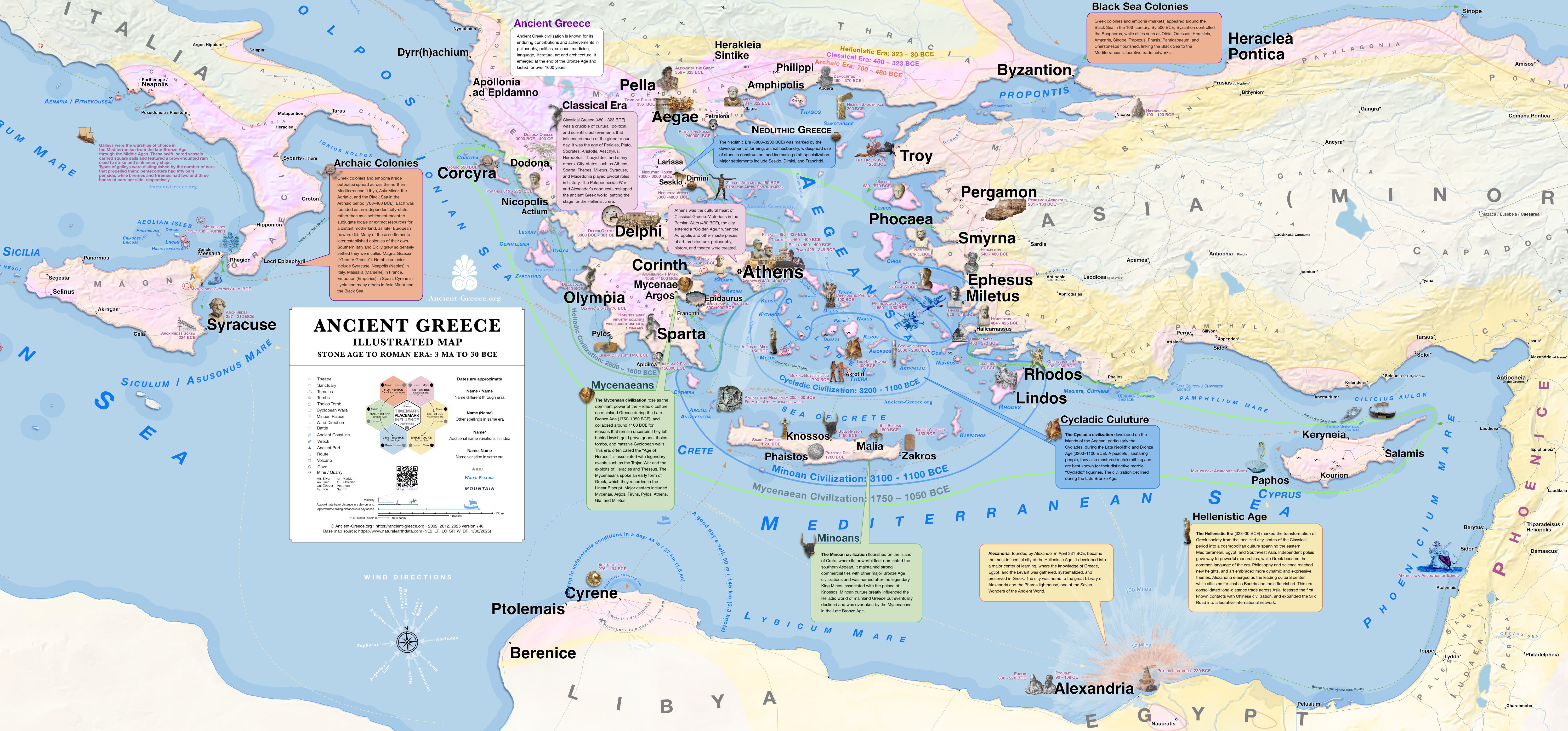
Detailed Map of Ancient Greece
Stone Age to Roman Era: 3 Ma – 30 BCE

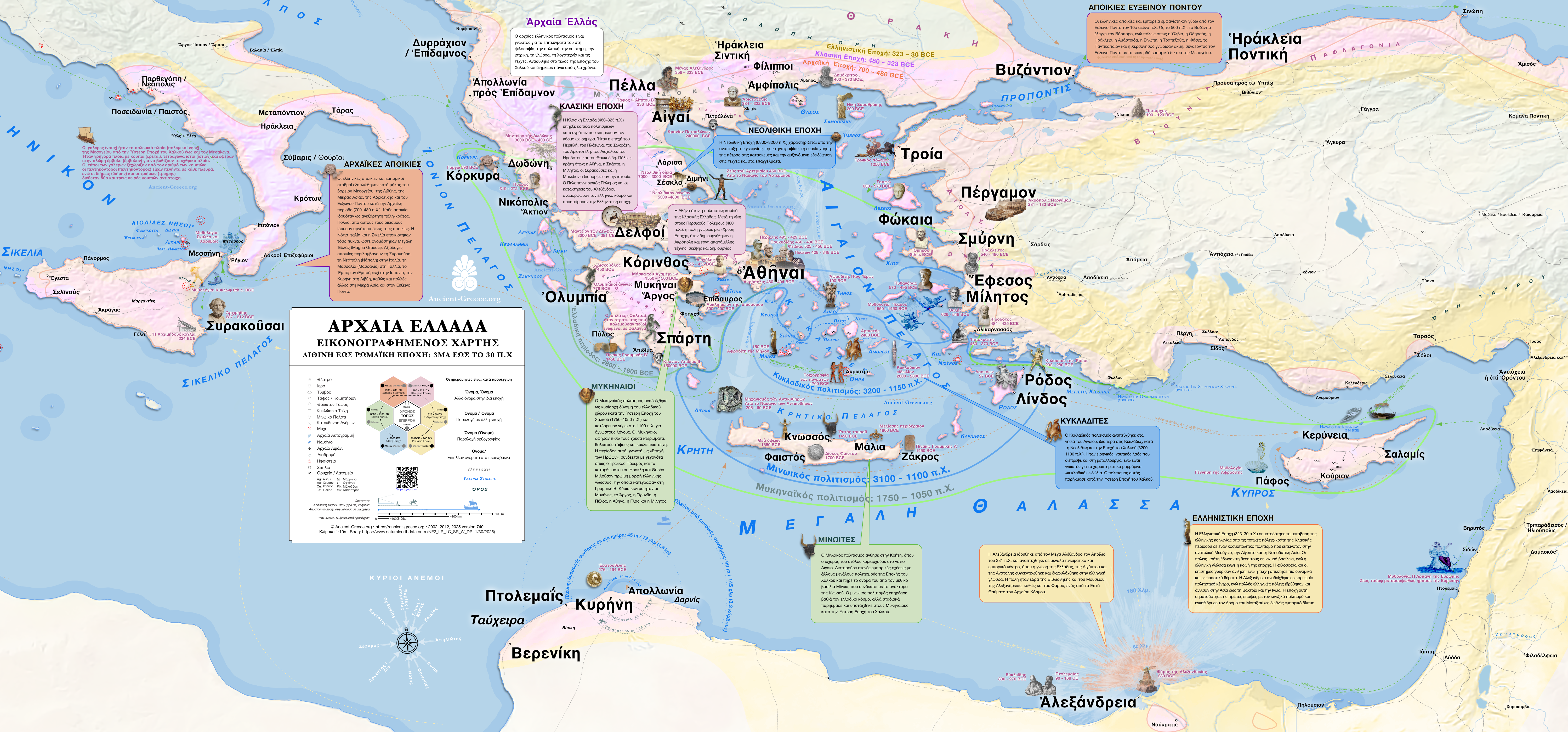
Ο πλέον λεπτομερής και πλήρης χάρτης μας, ως προς τη γεωγραφική κάλυψη της Αρχαίας Ελλάδας, περιλαμβάνει κάθε τοποθεσία που αναφέρεται στο ευρετήριο του χάρτη, από τη Λίθινη Εποχή έως τη Ρωμαϊκή Περίοδο, με κάθε σημείο να έχει τοποθετηθεί κατόπιν επαλήθευσης από αξιόπιστες πηγές (δείτε επίσης τη βιβλιογραφία).
PDF: Μεγέθυνση (Zoom) x10, Δυνατότητα Αναζήτησης, Διαστάσεις Εκτύπωσης 138,89 × 62,5 ίντσες (352,78 × 158,75 εκ.). Σημείωση εκτύπωσης: Σε οποιοδήποτε μέγεθος μικρότερο από το φυσικό, το κείμενο θα είναι υπερβολικά μικρό για να αναγνωσθεί.
Our most detailed and complete in area coverage map of Ancient Greece includes every place in the map index, from the Stone Age to the Roman Era, each hand-pinned after verification with trusted sources (also see the bibliography). In English and Greek.
PDF: Zoom x10, Search, Print 138.89 × 62.5 inches (352.78 × 158.75 cm). Printing note: Anything smaller than full size will have text too small to read.
Contents:
Ευρετήριο τοποθεσιών & πηγές
Η βάση δεδομένων περιλαμβάνει τον κατάλογο περισσοτέρων από 1700 οικισμών, με πρόσθετες ονομασίες και πηγές για τον καθένα.
Σημειώσεις του επιμελητή
Πληροφορίες σχετικά με την πρόοδο του χάρτη, τη διαδικασία υλοποίησης, τα επιμέρους στοιχεία, τον σχεδιασμό και την τεχνοτροπία.
Index of places & sources
The database contains the directory of over 1700 settlements with additional names and sources for each.
Editor’s notes
Information on the map progress, process, elements, design, and styles.
Illustrated Map of Ancient Greece
Stone Age to Roman Era: 3 MA – 30 BCE
In English: Illustrated Map of Ancient Greece
In Greek: Εικονογραφημένος Χάρτης της Αρχαίας Ελλάδας.
3 MA to 30 BCE
PNG: Zoom x4, Print 41.64 × 19.43 inches (105.76 × 49.35 cm)
Satellite View
3 MA ~ 200 CE
Ancient Greece Settlements Working File on Google Maps
Ancient Greece Settlements Working File on Google Earth
| Multiple eras | Stone Age | Bronze Age | Dark/Archaic Age | Classical Age | Hellenistic Age | Late Hellenistic / Roman |
 |  |  |  | |  |  |
| 8000 – 3000 BCE | 3000 – 1000 BCE | 1000 – 480 BCE | 480 – 323 BCE | 323 – 146 BCE | 146BCE+ |
Abridged Editions

Original files:
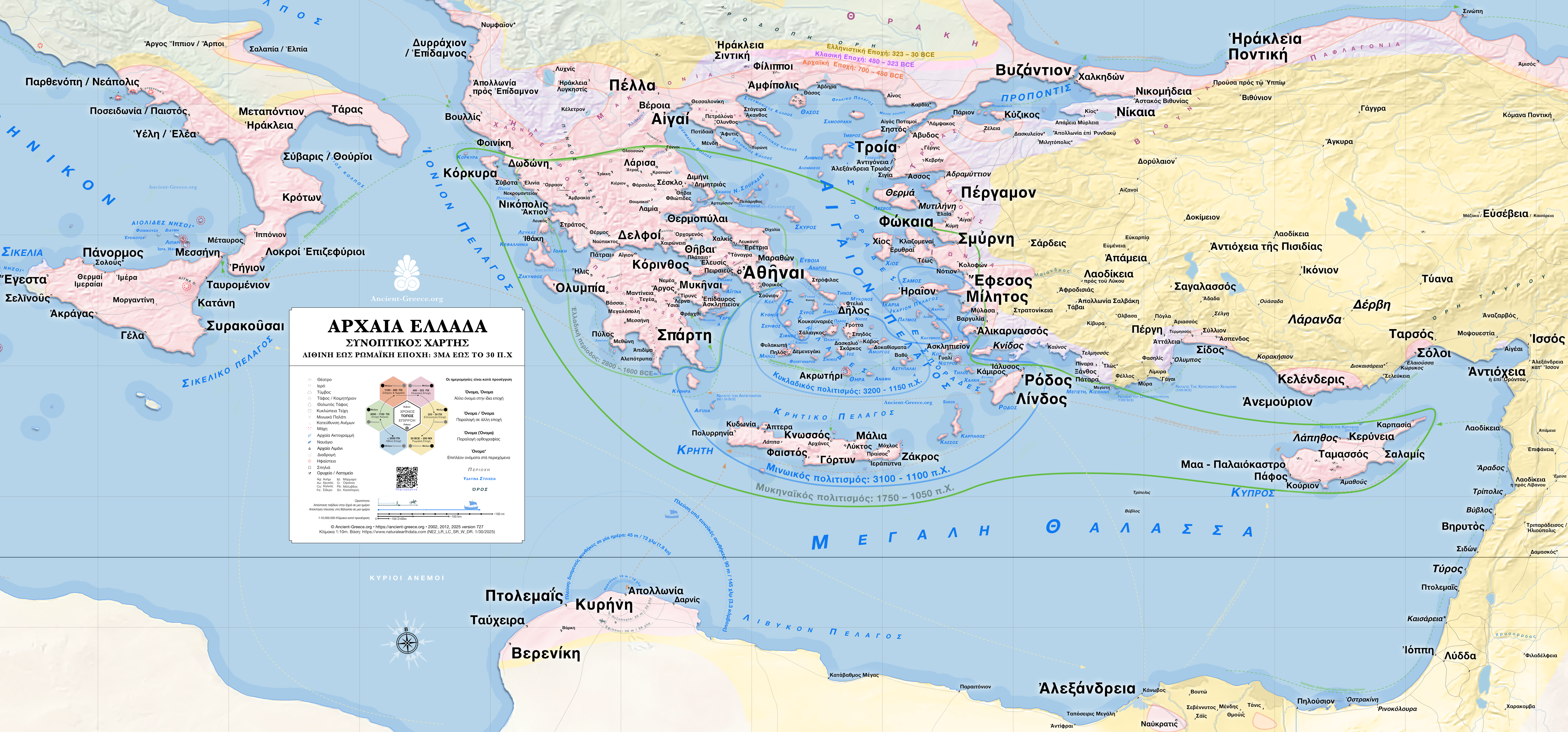
Detailed Map of Ancient Greece
Λεπτομερής Χάρτης της Αρχαίας Ελλάδας
3 MA to 30 BCE
PNG: Zoom x4, Print 41.64 × 19.43 inches (105.76 × 49.35 cm)
Original files:
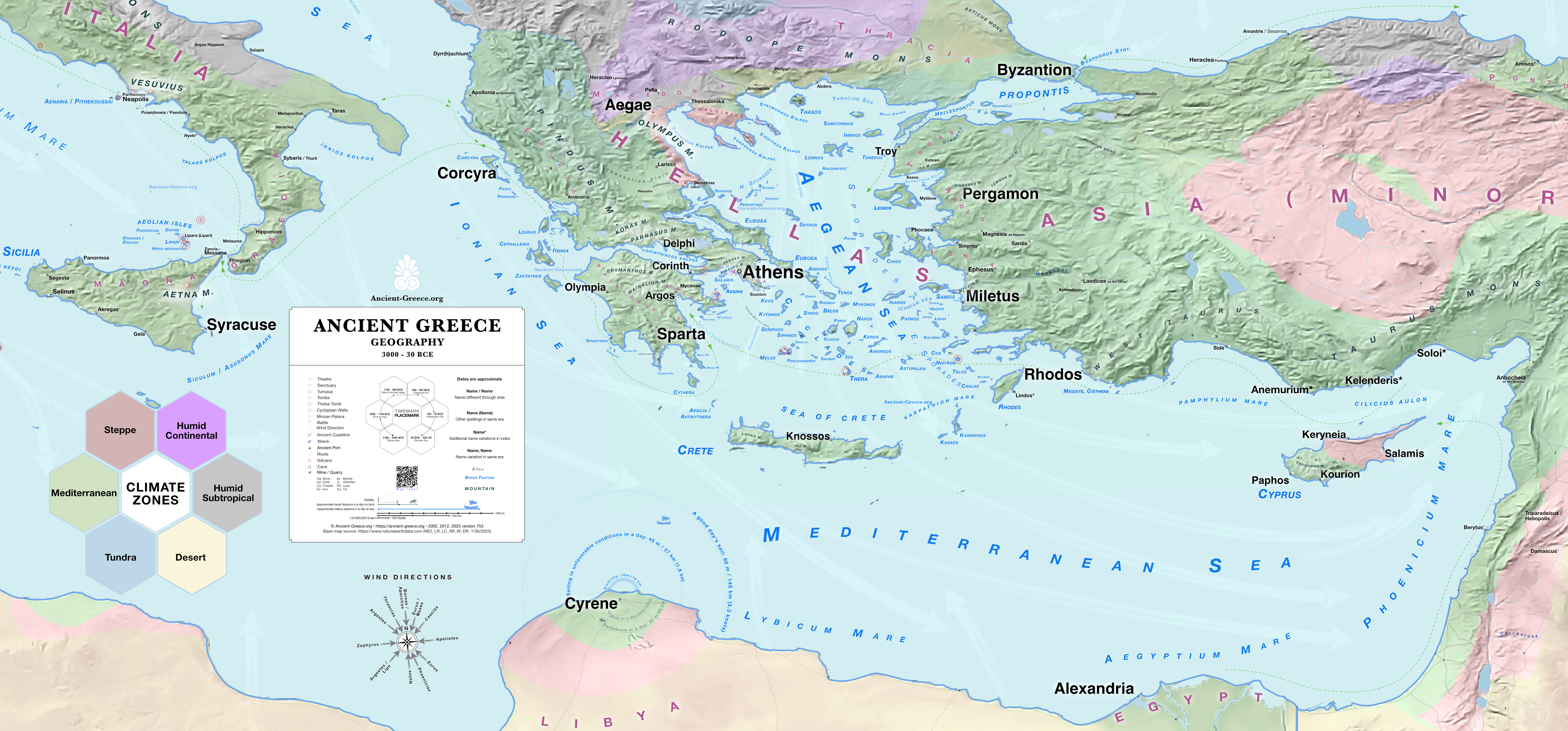
Geography
3000 to 30 BCE
.
PNG: Zoom x4, Print 41.64 × 19.43 inches (105.76 × 49.35 cm)
Original files:
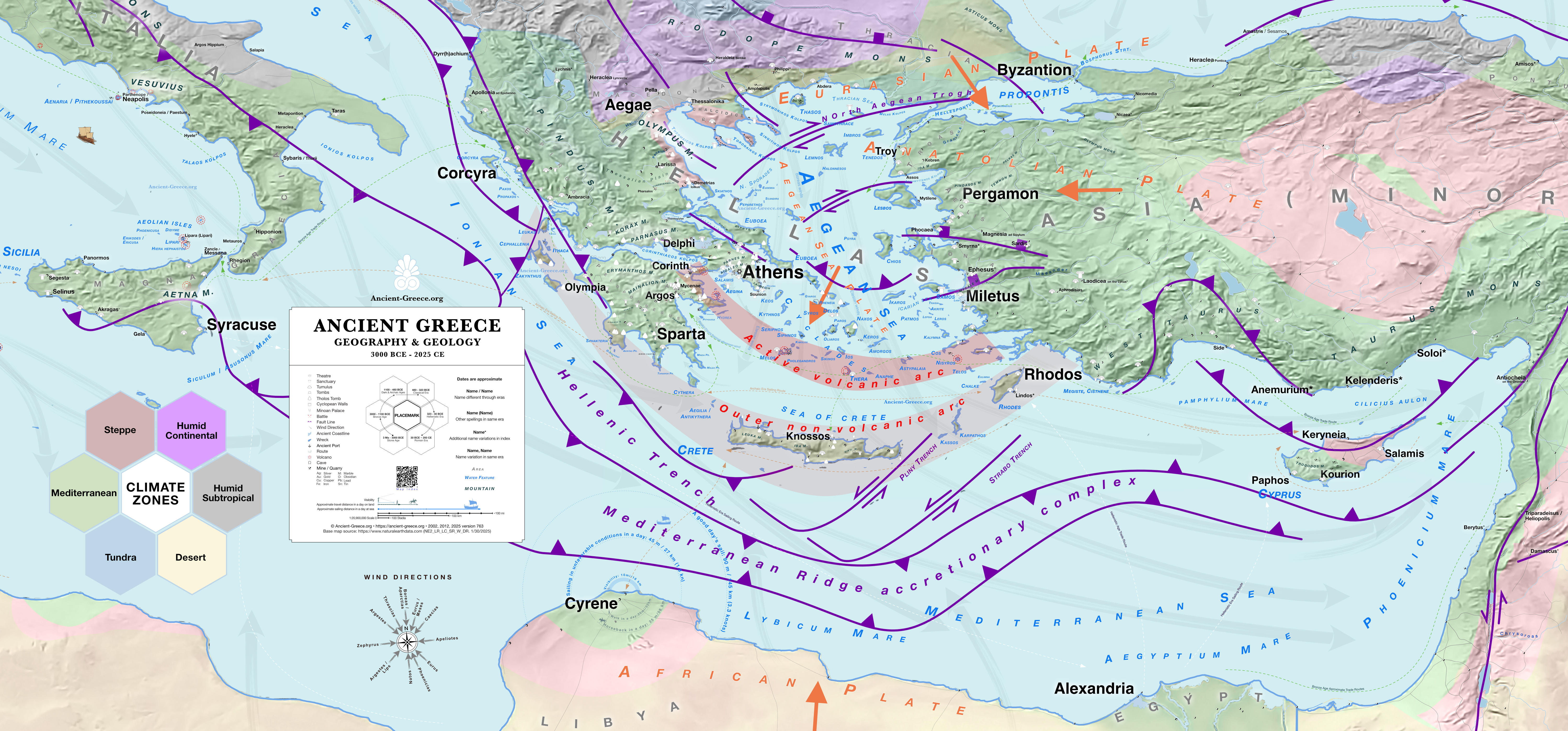
Geography and Geology
3000 BCE to 2025 CE
.
PNG: Zoom x4, Print 41.64 × 19.43 inches (105.76 × 49.35 cm)
Original files:
Highlights
Συνοπτικός χάρτης της Αρχαίας Ελλάδας
3 MA to 30 BCE
PNG: Zoom x4, Print 41.64 × 19.43 inches (105.76 × 49.35 cm)

Original files:
Stone & Bronze Ages: Cycladic, Minoan, Helladic, and Mycenaean civilizations
Λίθινη, και Εποχή του Χαλκού: Κυκλαδικός, Μινοϊκός, Ελλαδικός, και Μυκηναϊκός Πολιτισμός
3MA to 1100 BCE
PNG: Zoom x4, Print 41.64 × 19.43 inches (105.76 × 49.35 cm)
Original files:
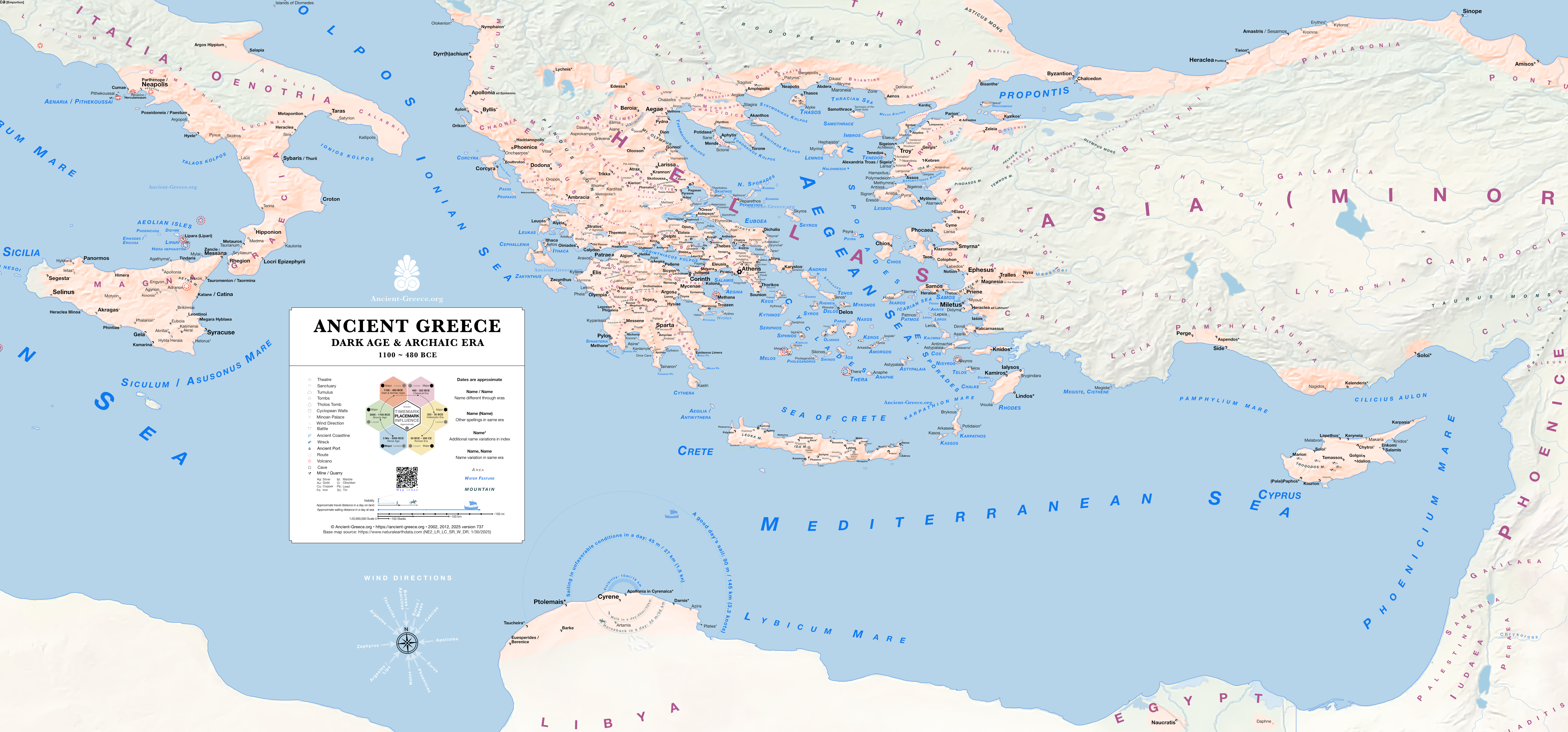
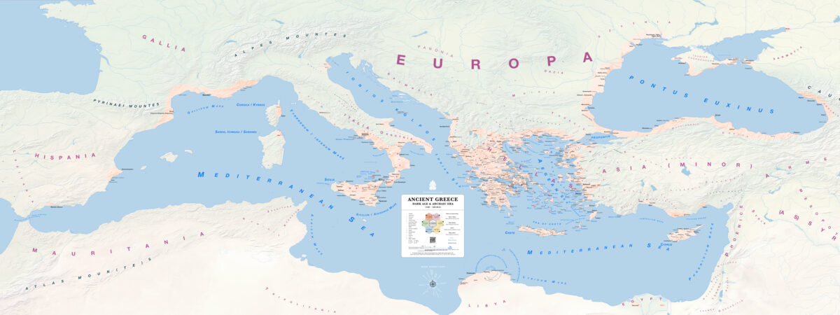
Dark Age and Archaic era Colonies
Η Αρχαία Ελλάδα κατά τον Σκοτεινό αιώνα και την Αρχαϊκή εποχή
1100 – 480 BCE
PNG: Zoom x4, Print 41.64 × 19.43 inches (105.76 × 49.35 cm)

Original files:
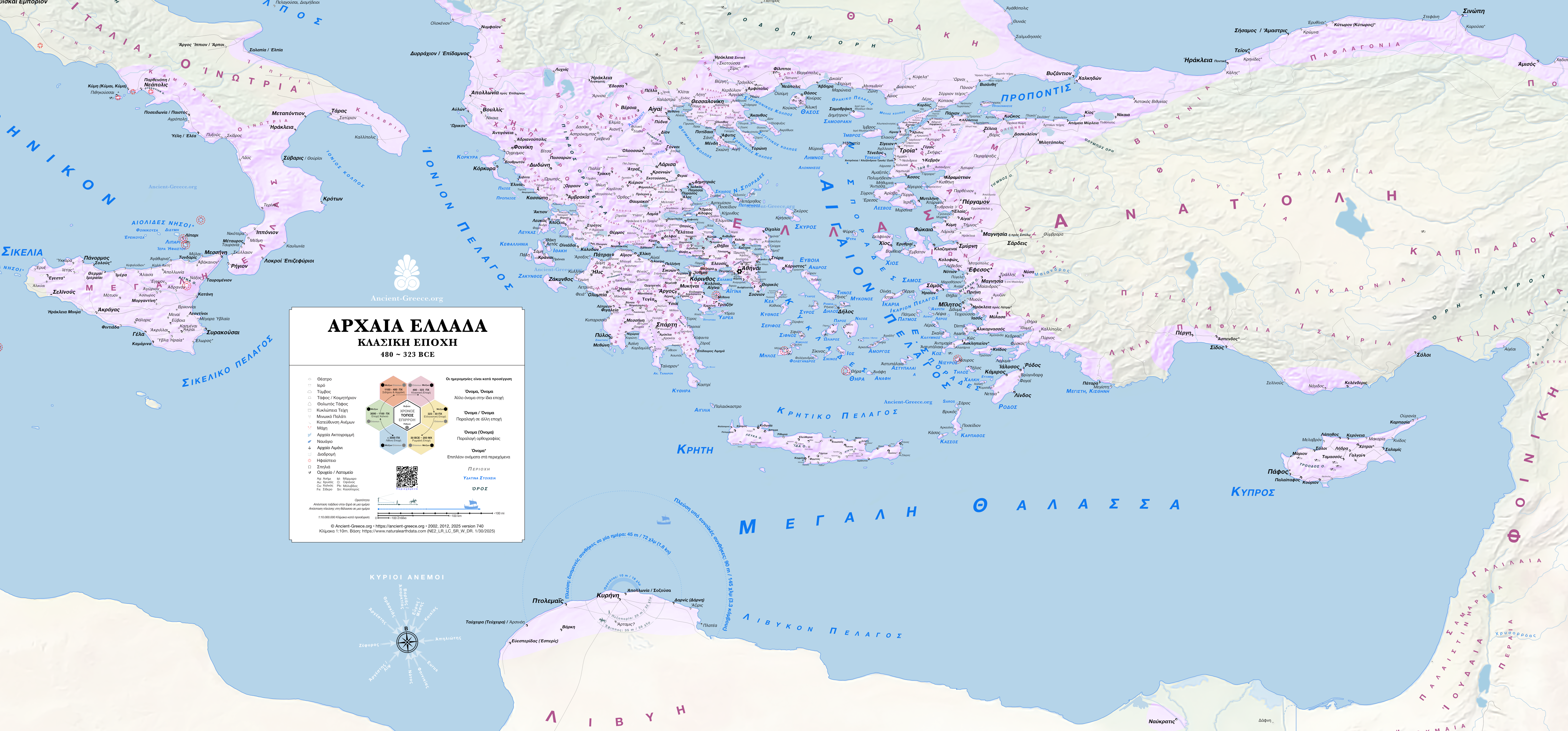
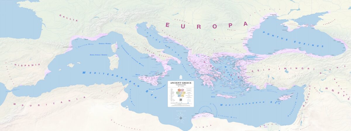
Classical Greece
Κλασική Εποχή
480 to 323 BCE
PNG: Zoom x4, Print 41.64 × 19.43 inches (105.76 × 49.35 cm)
Original files:
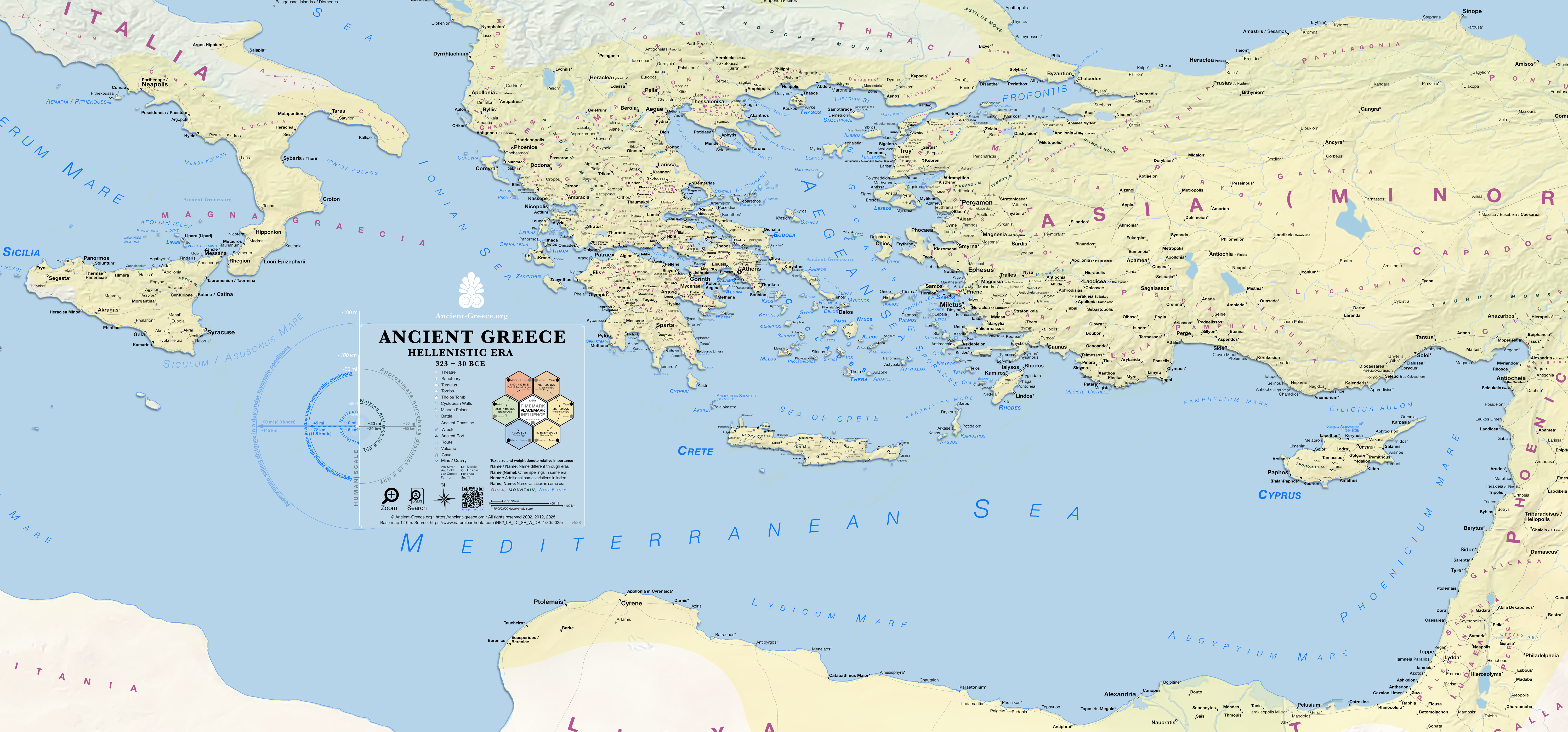
Hellenistic Era
323 BCE to 30 CE
PNG: Zoom x4, Print 41.64 × 19.43 inches (105.76 × 49.35 cm)
Map Gallery
Ancient Greece Map. Highlights. 3 Ma to 30 BCE. 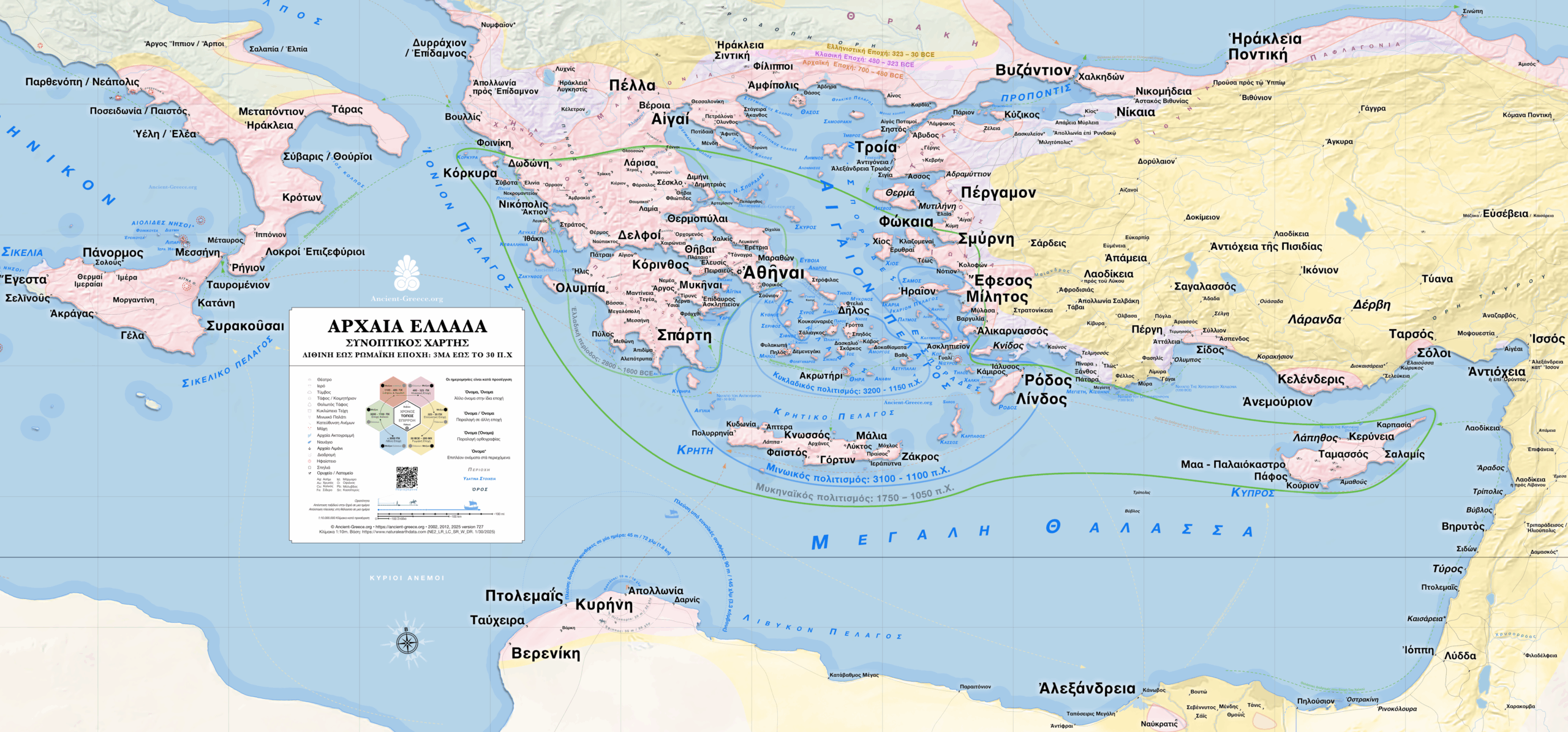
Χάρτης της Αρχαίας Ελλάδας. Συνοπτικός. Ανατολική Μεσόγειος. 3εκ-30 πΧ. 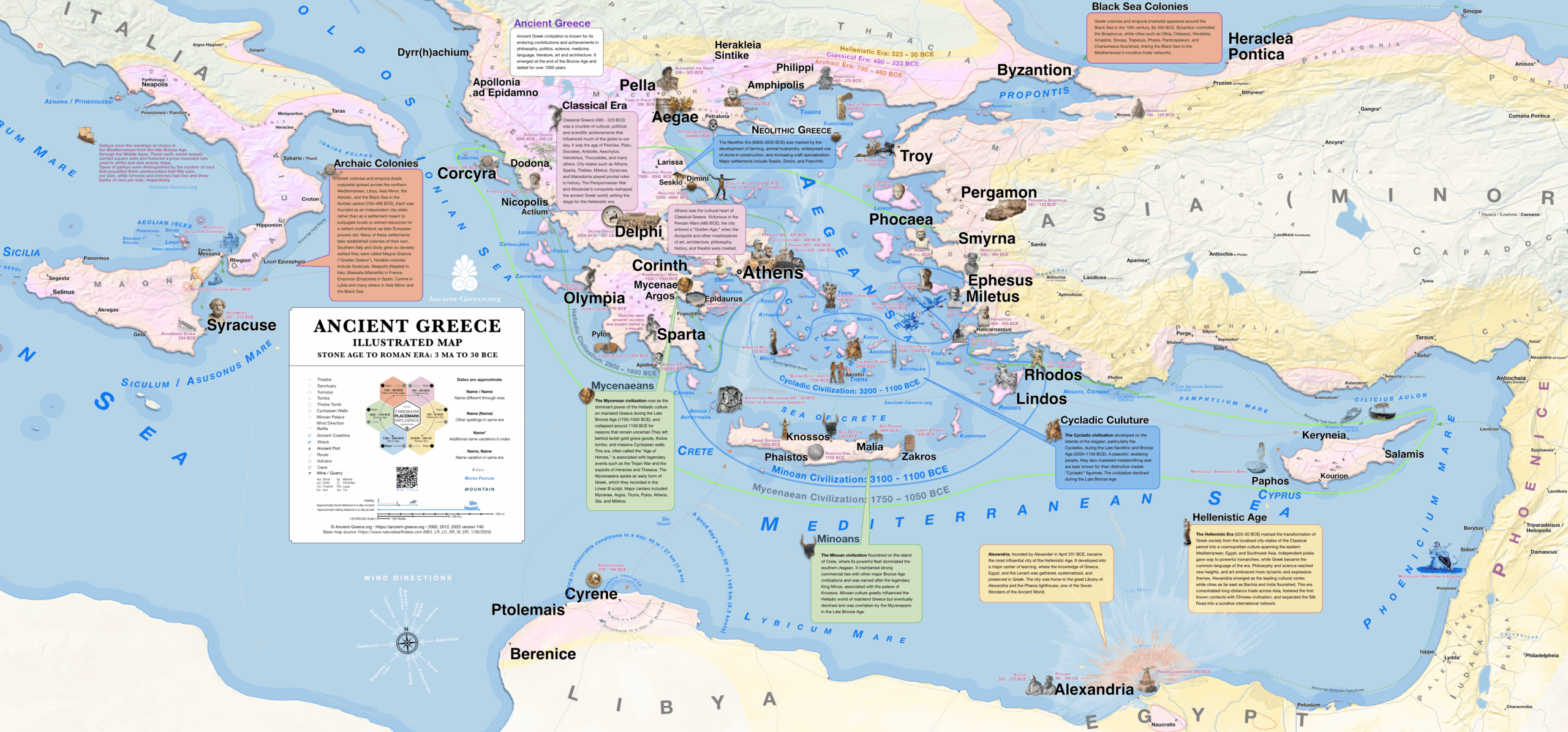
Illustrated Map of Ancient Greece. 3MA to 30 BCE. 
Εικονογραφημένος Χάρτης της Αρχαίας Ελλάδας. Ανατολική Μεσόγειος, από το 3 MA έως το 30 πΧ. 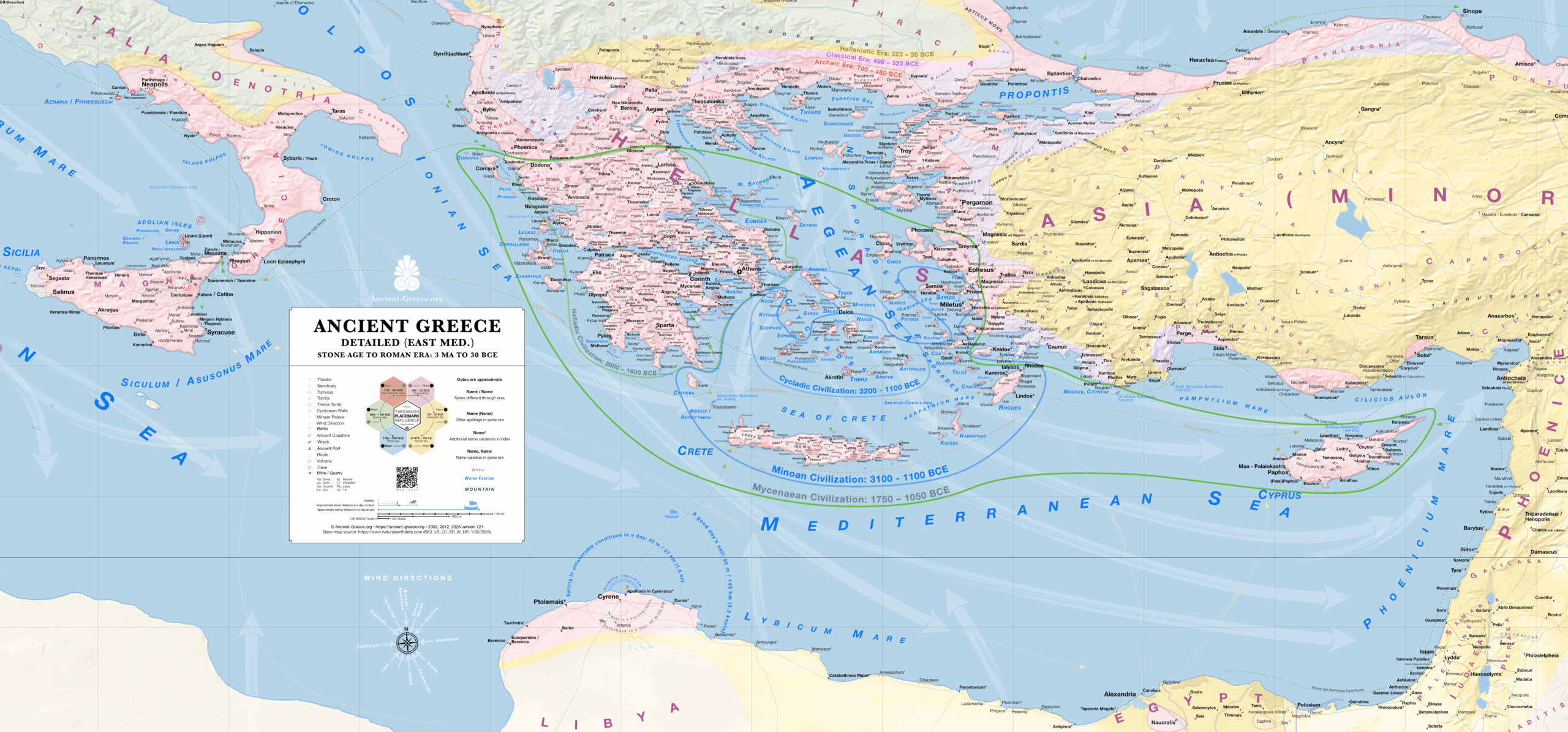
Ancient Greece Map. Detailed (East Med) 3.5M to 30 BCE. 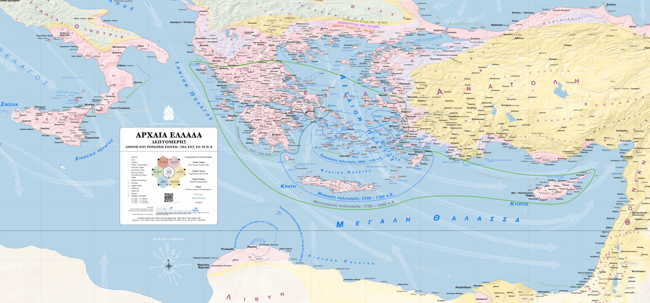
Λεπτομερής Χάρτης της Αρχαίας Ελλάδας. Ανατολική Μεσόγειος. Από το 3 εκ έως το 30 πΧ 
Ancient Greece Map. Complete (pre3000 to 30 BCE). 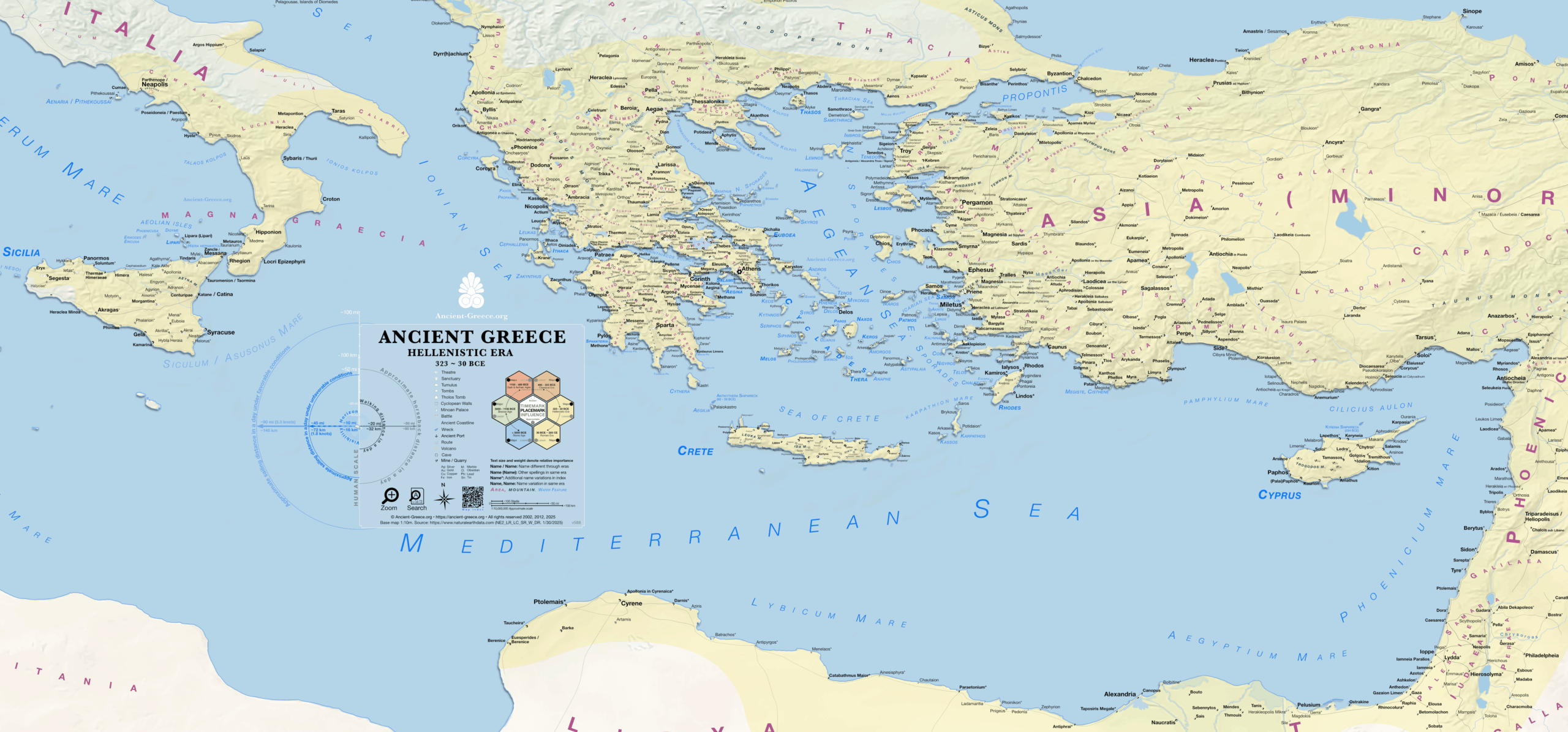
Ancient Greece Map: All the settlements of the Hellenistic Era (323 to 30 BCE) around the Eastern Mediterranean. 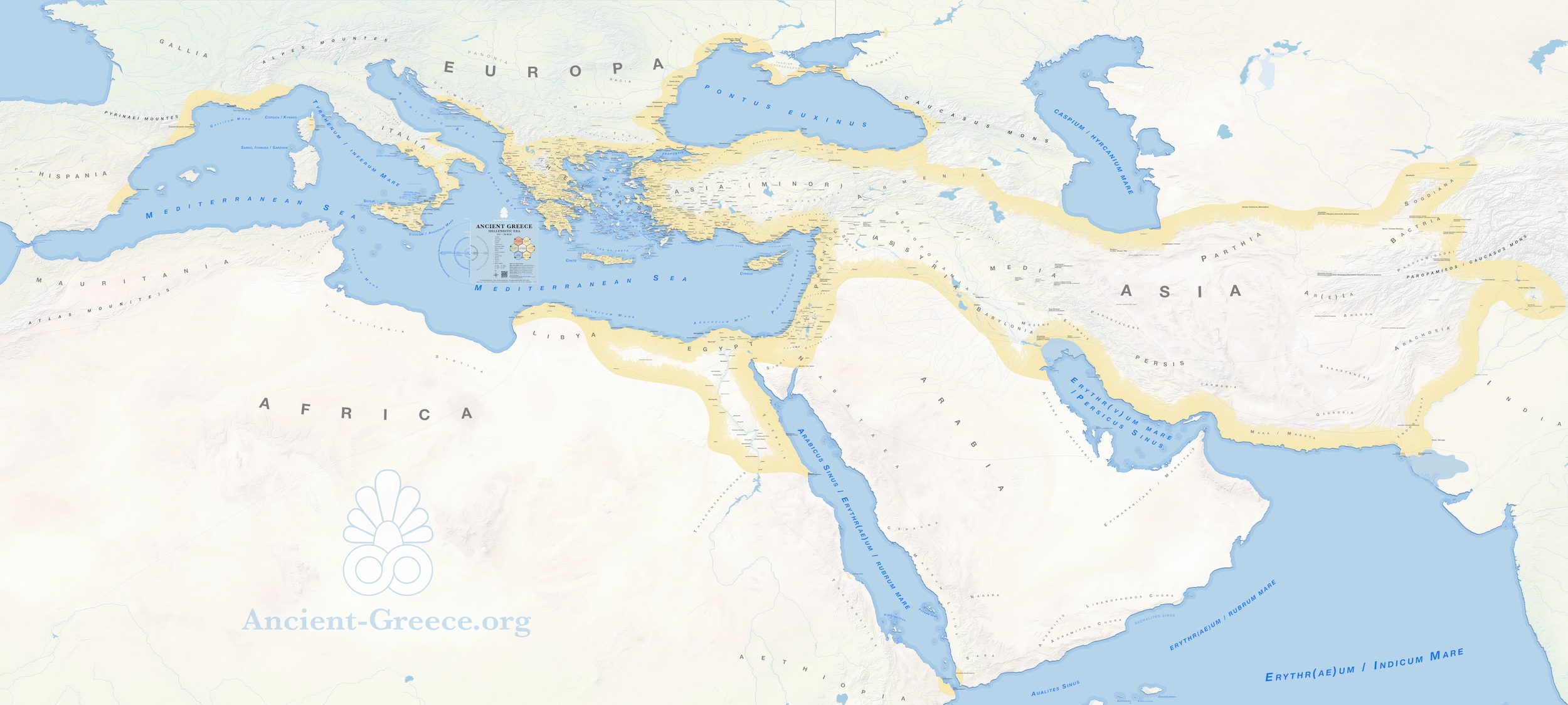
Ancient Greece Map. Hellenistic Era (323 to 30 BCE). 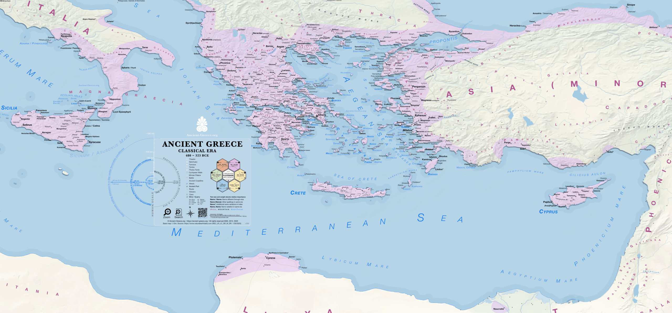
Ancient Greece Map: The Classical Era (480 to 323 BCE). Partial map centered on the Eastern Mediterranean. 
Χάρτης της Αρχαίας Ελλάδας κατά την Κλασική Εποχή. 480 εως το 323 πΧ. 
Χάρτης της Αρχαίας Ελλάδας κατά την Κλασική Εποχή. 480 εως το 323 πΧ. 
Ancient Greece Map Dark and Archaic Era 1100 to 480 BCE. 
Map of Ancient Greece During the Dark and Archaic Eras. 1100 to 480 BCE. 
Προϊστορική Ελλάδα: Από την Παλαιολιθική στην Εποχή του Χαλκού (≈400.000−1100 π.Χ.) 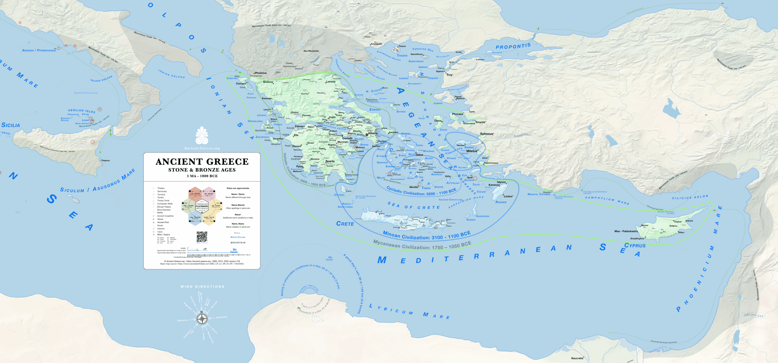
Map of Ancient Greece during the Stone and Bronze Ages. 3 MA to 1100 BCE. 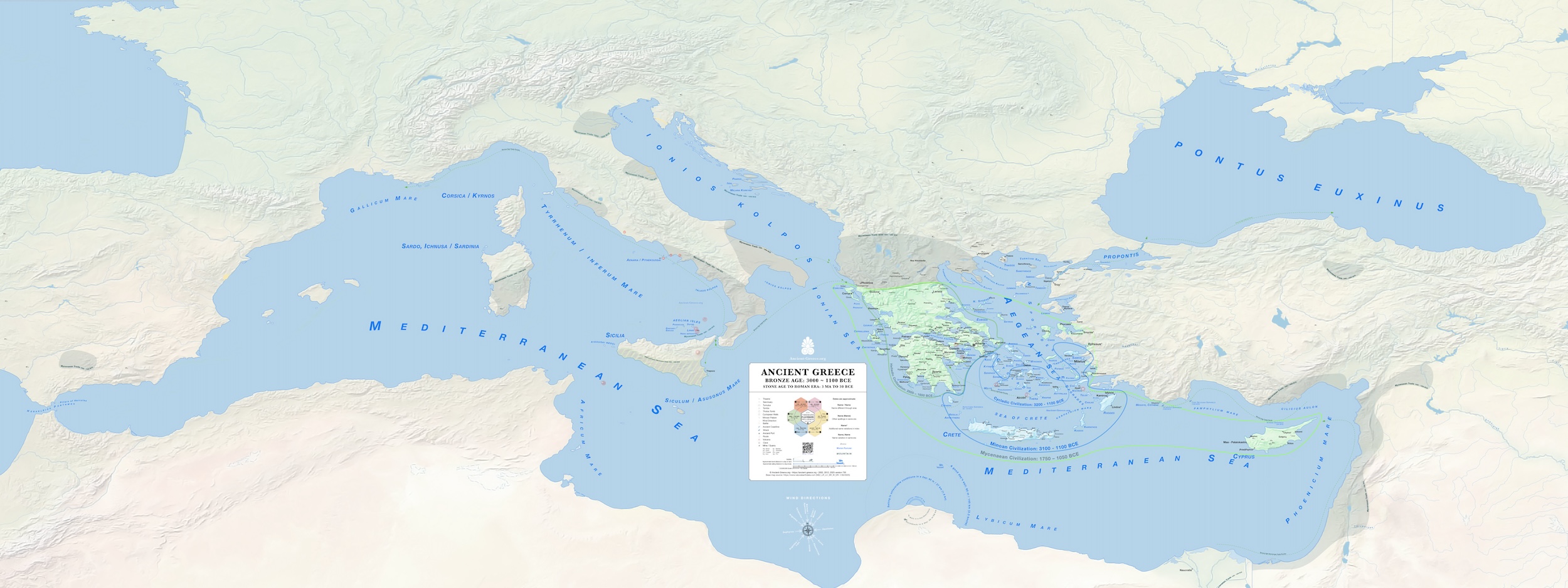
Thumbnail of Ancient Greece Map. Stone and Bronze Ag. 3 MA to 1100 BCE. 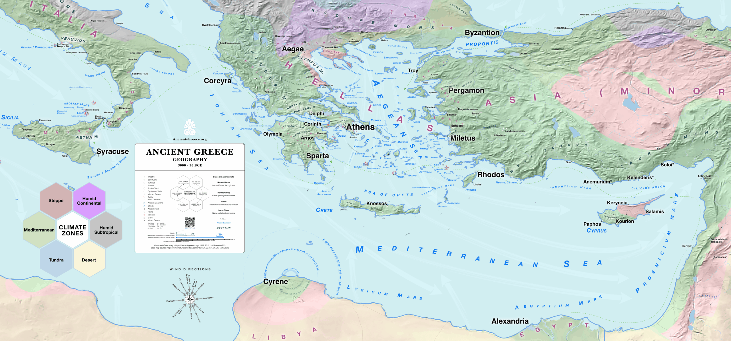
Geography of Ancient Greece. 3000 BCE to 30 BCE. 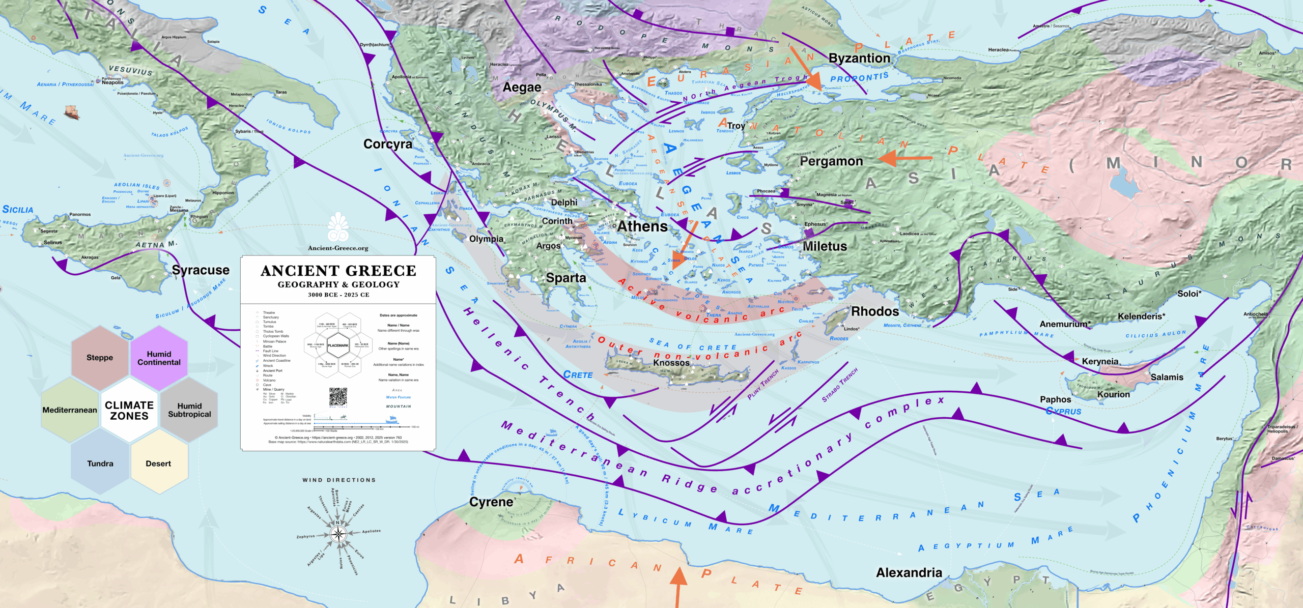
Ancient Greece – Geography and Geology – 3000 BCE to 2025 CE
This slideshow illustrates Ancient Greece through map previews.
For high quality maps and to see more details, open or download the free original files found on this page.
Detailed Maps By Era

Original files:
Stone & Bronze Age civilizations: Cycladic, Minoan, Helladic, and Mycenaean
Λίθινη, και Εποχή του Χαλκού: Κυκλαδικός, Μινοϊκός, Ελλαδικός, και Μυκηναϊκός Πολιτισμός
3 Ma to 1100 BCE
PDF: Zoom x10, Search, Print 83.34 × 31.25 inches
211.68 × 79.37 cm
Original files:
Dark Age and Archaic Era Colonies
Σκοτεινη και Αρχαϊκή Εποχή
1100 – 480 BCE
.
.
PDF: Zoom x10, Search, Print 83.34 × 31.25 inches
211.68 × 79.37 cm
Original files:
Classical Greece
Κλασική Εποχή
480 to 323 BCE
.
.
PDF: Zoom x10, Search, Print 83.34 × 31.25 inches
211.68 × 79.37 cm
Original files:
Hellenistic Era
Ελληνιστική Εποχή
323 BCE to 200 CE
.
PDF: Zoom x10, Search, Print 138.89 × 62.5 inches
352.78 × 158.75 cm
About
Ο σκοπός του έργου είναι α) η δημιουργία ενός ολοκληρωμένου και εμπεριστατωμένου χάρτη της Αρχαίας Ελλάδας που να περιλαμβάνει όλες τις γνωστές και πιθανές τοποθεσίες, και β) ένας χάρτης που να είναι ενημερωτικός, ακριβής και οπτικά καλαίσθητος τόσο σε έντυπη όσο και σε ψηφιακή μορφή. Κατά τη διαδικασία, κάθε σημείο τοποθετήθηκε στον χάρτη αφού ελέγχθηκε και επαληθεύτηκε μία προς μία με αξιόπιστες πηγές, οι οποίες βρίσκονται στο Ευρετήριο του Χάρτη και στη Βιβλιογραφία.
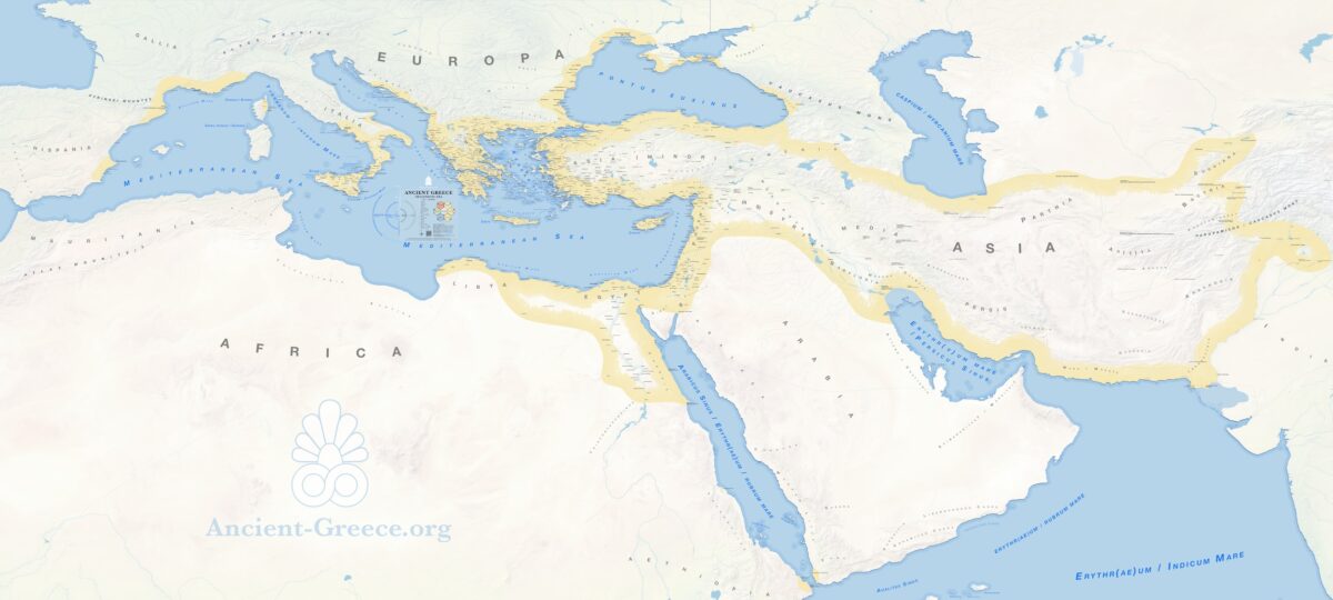
Οι χάρτες περιλαμβάνουν τοποθεσίες εντός της σύγχρονης χώρας, καθώς και περιοχές εκτός αυτής οι οποίες κατά την αρχαιότητα κατοικήθηκαν κυρίως από Έλληνες, ή υπήρξαν κέντρα ελληνικής επιρροής, ή εξελληνίστηκαν, ή διοικήθηκαν από Έλληνες, από τη Λίθινη Εποχή έως τη Ρωμαϊκή Περίοδο (προ του 3000 π.Χ. έως περίπου το 200 μ.Χ.). Περιγράφει την έκταση του Ελληνικού Πολιτισμού από την Ισπανία έως την Ινδία, και από τη Μαύρη Θάλασσα έως την Αίγυπτο, ξεκινώντας από τα βάθη της Λίθινης Εποχής και καταλήγοντας στην Ύστερη Αρχαιότητα (περίπου το 200 μ.Χ.).
Εν συντομία, οι χάρτες περιλαμβάνουν τοποθεσίες που ένας μελετητής ή ερευνητής της ιστορικής περιόδου θα έβρισκε χρήσιμες.
Ο Λεπτομερής • Πλήρης χάρτης της Αρχαίας Ελλάδας έχει σχεδιαστεί για να αποτελέσει τον απόλυτο σύντροφο για τη μελέτη και την έρευνα στην Αρχαία Ελλάδα. Περιλαμβάνει κάθε κύριο και δευτερεύοντα οικισμό που υπάρχει στο ευρετήριο. Οι σκιασμένες περιοχές και τα έγχρωμα περιγράμματα αναδεικνύουν τη μέγιστη εξάπλωση του πολιτισμού σε κάθε ιστορική περίοδο. Δεν αποτελούν «σύνορα» ή «αυτοκρατορίες», αλλά επισημάνσεις της έκτασης και της ανάπτυξης του πολιτισμού ανά τους αιώνες.
Ως επί το πλείστον, ο οπτικός σχεδιασμός αποδίδει φόρο τιμής στους παλιούς σχολικούς χάρτες τοίχου και τα εγχειρίδια γεωγραφίας των τελών του 20ού αιώνα, αν και ορισμένοι θεματικοί χάρτες διαθέτουν πειραματικό στυλιστικό ύφος.
Αυτοί οι χάρτες ενσωματώνουν την έρευνα του επιμελητή πάνω στην Αρχαία Ελλάδα και τον σχεδιασμό πληροφοριών (information design). Ως εκ τούτου, ο χάρτης είναι ένα ζωντανό έγγραφο σε συνεχή ανάπτυξη, με νέες προσθήκες, διορθώσεις και τροποποιήσεις σε κάθε έκδοση. Οι αριθμοί έκδοσης βρίσκονται στο υπόμνημα του χάρτη.
Η ανάπτυξη ξεκίνησε το 2002 και το έργο έφτασε στην ωριμότητά του το 2025, στην έκδοση 400, με νέο βασικό χάρτη και το 99% των οικισμών επαληθευμένο και τοποθετημένο.
Αυτοί οι αποκλειστικοί χάρτες είναι δωρεάν για προσωπική χρήση, αλλά δεν επιτρέπεται η αναπαραγωγή, η αναδιανομή, η ενσωμάτωση, η μετάφραση ή η δημοσίευση σε οποιαδήποτε μορφή ή μέσο, η πώληση ή η εκ νέου αδειοδότηση. Διαβάστε περισσότερα σχετικά με την κατάλληλη χρήση…
The goal of this project is a) to create a comprehensive and thorough map of Ancient Greece that includes all known and probable locations, and b) to produce a map that is informative, accurate, and visually pleasing in both printed and digital formats. During the process, every point was plotted on the map only after being checked and verified one by one against reliable sources, which can be found in the Map Index and the Bibliography.
The maps include locations within the modern country as well as regions beyond its borders which, in antiquity, were predominantly inhabited by Greeks, served as centers of Greek influence, were Hellenized, or were administered by Greeks—spanning from the Stone Age to the Roman Era (pre-3000 BCE to approximately 200 CE). It describes the reach of Greek Civilization from Spain to India, and from the Black Sea to Egypt, beginning from the depths of the Stone Age and concluding in Late Antiquity (c. 200 CE).
In short, the maps include locations that a scholar or researcher of this historical period would find essential.
The Detailed • Complete map of Ancient Greece is designed to be the ultimate companion for studying and research in Ancient Greece. It includes every major and minor settlement in the index. Shaded areas and colored outlines highlight the maximum expansion of the civilization in each historical period. These do not represent “borders” or “empires,” but rather markers of the extent and development of the civilization over the centuries.
For the most part, the visual design pays tribute to the old school wall maps and geography textbooks of the late 20th century, though some thematic maps feature experimental stylistic approaches.
These maps integrate the editor’s research on Ancient Greece and information design. As such, the map is a living document in constant development, with new additions, corrections, and amendments in each version. Version numbers are located in the map legend.
Development began in 2002, and the project reached maturity in 2025 with version 400, featuring a new base map and 99% of settlements verified and plotted.
These exclusive maps are free for personal use, but reproduction, redistribution, embedding, translation, or publication in any form or medium, sale, or sub-licensing is not permitted. Read more about appropriate usage…